
On the 26th anniversary of the founding of the University of the Philippines’ Archaeological Studies Program (UP-ASP) on August 24, 2021, an architect named Michael Tabao presented a paper: “Cagayan’s Chessboard: Mapping and Visualizing the Rise and Fall of the 18th Century Spanish Fortifications in Cagayan Valley.” Michael was a Cagayano and an instructor at the University of St. Louis, Tuguegarao City. The talk piqued my interest because Michael was presenting information previously unknown to me about Isabela, my father’s home province, and Cagayan (Fig. 1). At the same time, Dr. Grace Barretto-Tesoro was also keenly listening in on the talk. Grace was foreseeing the usefulness of the information for the PANTROPOCENE project. Future study of these forts fits well with her interest in testing the correlation between the construction of stone structures with changes in settlement patterns as well as the environmental effects these changes initiated.
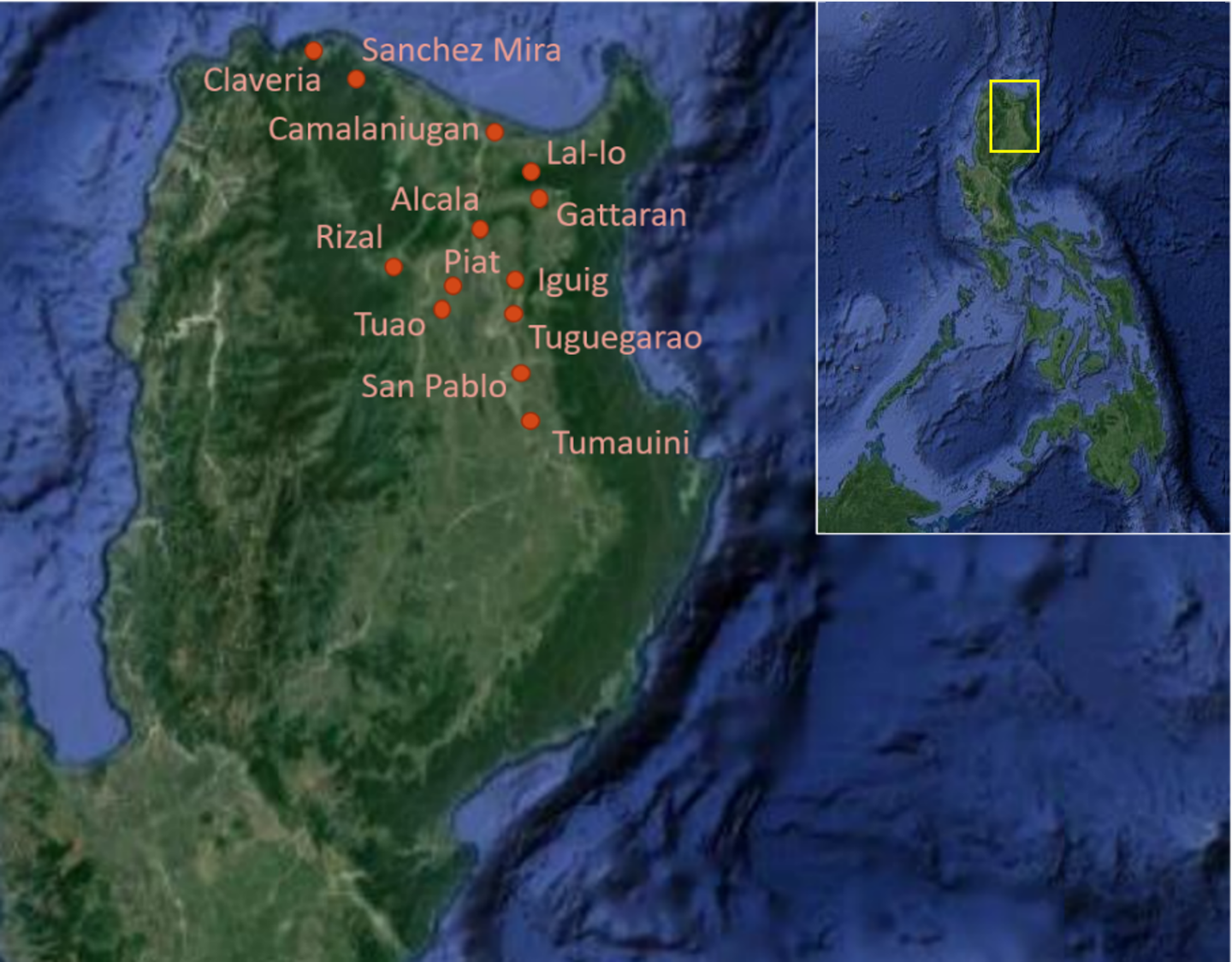
Figure 1. Map of study areas mentioned in text (Adapted from Google Earth by M. Mabanag)
In mid-2021, Mylene Lising, an ASP alumna and a heritage specialist who has worked in Kalinga and Cagayan, organized a lecture series called “Cagayan Heritage Conversation Series” and invited Grace to collaborate on a project. One year later and the ASP team, consisting of Grace, Dr. Leee Neri, a professor specializing in historical archaeology at ASP, and Arcadio Pagulayan, a support staff member of the PANTROPOCENE, and I, finally went to Tuguegarao to meet with Michael, Mylene, and Kevin Baclig, curator of the Cagayan Museum and Historical Research Center, to start what was a long five-day slog that spanned the reaches of Cagayan as well as a couple of locations in the province of Isabela. As most of the forts Michael referenced in his talk are no longer standing and their locations are not very well indicated in historical maps, we ultimately decided to concentrate our efforts on Spanish-era stone churches and other structures to explore the changing patterns and environmental impacts of built architecture in the region.
We travelled around 750 kilometers within the reaches of the Cagayan Valley during the survey period. Our survey covered towns like Claveria and Sanchez Mira in northwestern Cagayan, Camalaniugan, Lal-lo and Gattaran in the northeast, and the sites of Tuguegarao, Iguig, Rizal, Piat, Alcala, and Tuao in the south. On our way back to Manila, we passed through San Pablo and Tumauini, just off the Cagayan River in Isabela, to investigate a few sites there as well. In all, we surveyed 26 potential sites, all stone-based structures such as churches, forts, and a few hornos (kilns). We relied on Kevin, Michael, and Mylene for suggesting sites to survey based on their knowledge of historical records of their home province.
We were warmly welcomed in all of the towns we visited. All the representatives we spoke with expressed their eagerness to collaborate with future historical and archaeological research we may undertake. This is in no small way because of Mylene and Kevin. The work they did in reaching out to the different local government units (LGUs) prior to our visit to Cagayan made our survey seamless. We also sent letters of introduction to the Cagayan Governor and to the Mayors of the towns included in our list, but the reception we received was almost certainly the result of the work of our local collaborators. This account of our survey of sites in parts of Cagayan and Isabela does not follow a chronological sequence of our travels, but rather follows a general geographic approach. I have divided up the survey area into southern Cagayan, northeastern Cagayan, northwestern Cagayan, and Isabela regions.
Southern Cagayan
Tuguegarao City served as our base for the majority of the survey (we also stayed in Pamplona in the northwest), and we surveyed a few localities that have historical importance to the region while there. One of the first sites we visited was Iglesia de Santiago Apostol or Iguig Church in the town of Iguig (Noche 2004). Completed in 1787, perhaps the most notable feature of the church is the presence of flying buttresses on its apse (Fig. 2). Quite an uncommon architectural design in the churches in Cagayan but, according to Michael, flying buttresses as support structures were generally utilized as a workaround for want of abundant materials.
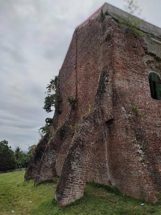
Figure 2. Flying buttresses of Iguig Church (Photo by M. Mabanag)
Another feature of the church complex is one of the more well-preserved hornos in Cagayan Valley (Macarrubo 2019) (Fig. 3). The bricks used for the construction of the church were most probably made here. The location of the church is on a rolling knoll overlooking the Cagayan River, approximately 77 metres above sea level (masl). Presently, the land southeast of the stone structure has been fashioned into a small park with a prominent cross on an altar built on top of the horno (the columns of the kiln are flanking the crucifix).
Southeast of Iguig Church, in a square just across the road, but part of the church compound still, there was a red-brick well with excavation happening beside it. The excavation has a depth of about one metre. The sediment was primarily of loose sand clay, and on the West wall there were layers with charcoal starting around 40cm down. Aside from this, we were able to find a few pieces of stoneware and porcelain sherds on the terminal layer which may point to its age. We collected the artifacts and accessioned them when we arrived in Manila. Future archaeological excavations will be plotted in the back area of the church grounds with at least one square also allotted in a cleared area downslope near where present corn stands are now located.
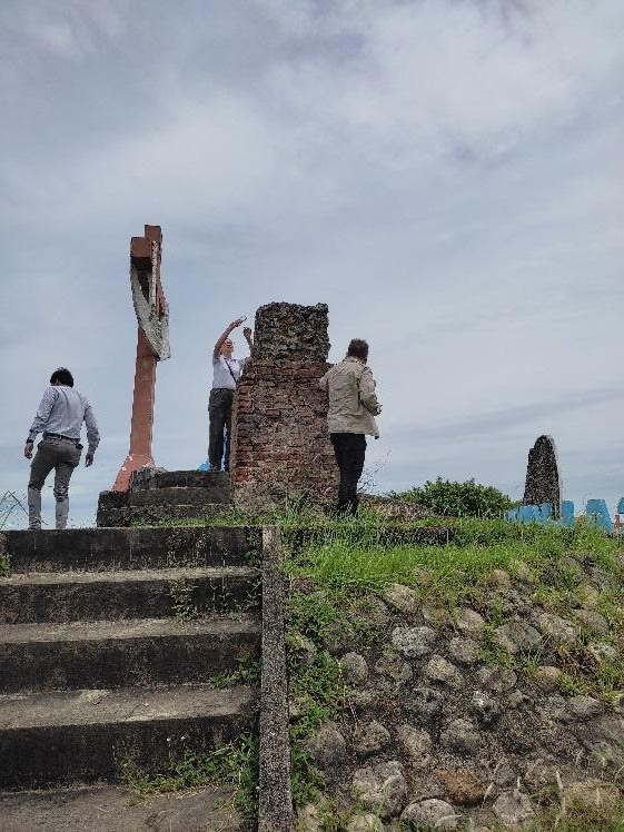
Figure 3. Columns of Iguig horno (Photo by M. Mabanag)
In Tuguegarao City we also visited a few historically-significant sites such as the St. Peter Metropolitan Cathedral, Ermita de San Jacinto, and three horno sites. St. Peter, also known as the Tuguegarao Cathedral, was completed in 1766 after five years. The architectural design of the cathedral also includes flying buttresses at the apse that have since been converted to a small chapel for the reservation, exposition and worship of the Eucharist by covering the arches of the buttresses with cement. The bricks came from the same hornos that produced the materials to construct Iglesia y Ermita de San Jacinto that was completed in 1724. An earlier version of the chapel was established as a visita in 1604, however (Macarrubo 2019; see also Noche 2004). The surrounds of St. Peter and San Jacinto as well as the kiln sites located by the Pinacanauan River unfortunately cannot be studied archaeologically. Their grounds are cemented and leave no space to allow for excavations to be done. Leee, towards the end of our survey, shared that he has not seen hornos quite as big in his experience working in Mindanao.
The Church of Malaueg (or San Raymundo de Peñafort Church) (Fig. 4) in Rizal, Cagayan can be dated to the early 17th Century—the laying of the first stone was on November 21, 1617. Located by a tributary of the Chico River (which itself links with the Cagayan River) called Matalag River, the church was named after the language spoken by the Indigenous peoples that settled in the valley (Jose 2011b). Aside from the church, there are the ruins of a convent within its grounds. The convent grounds are overgrown with vegetation, but the walls are very much still standing. The location of the church and convent grounds appear to be on a promontory (estimates of 70 masl), and to the northeast one can see the land sloping down. Following a concrete staircase leading down from the grounds led me to a community that was less than 100 metres west of a bend of the Matalag River.
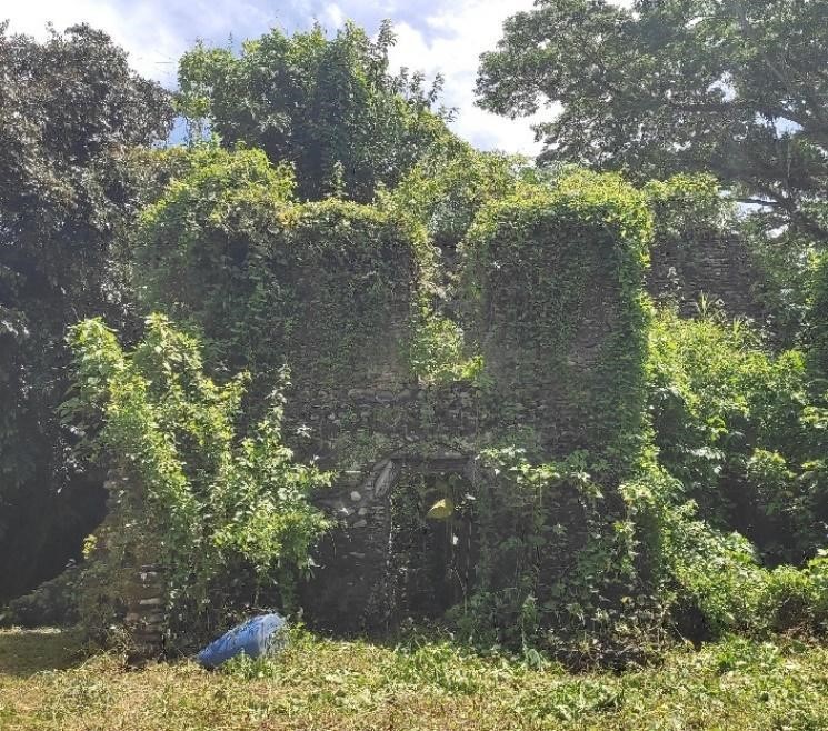
Figure 4. Older apse of Malaueg Church in Rizal (Photo by M. Mabanag)
Southeast of Rizal, the town of Piat was established as a mission in 1610. The church itself, Iglesia de Santo Domingo de Guzman was built in 1740 (Noche 2004), and now lies in ruins (Fig. 5) south-southwest of the current Our Lady of Piat High School. According to Michael, what remains of the historical church is the apse at the back of the school building. Aside from the apse, one can see structures with distinct buttresses and arches made of red brick in a few standing walls that may have been part of the convent. The materials to construct the church and convent may have been manufactured in a horno in Brgy. Poblacion 1. The top of the kiln itself overlooks Chico River, less than 30m away.
Alcala (formerly named Fulay) is a town that started as an ecclesiastical mission in 1845 under the patronage of Santa Filomena, Virgen y Martir. The church, still named after the patron saint, came much later in 1881 (Noche 2004), and was one of the later built churches we covered in our survey.
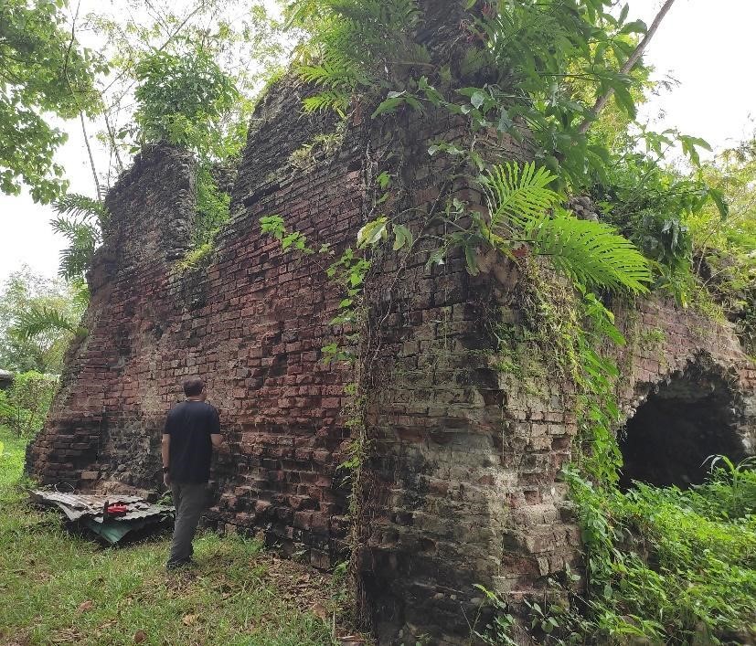
Figure 5. Possible wall of convent in Iglesia de Santo Domingo de Guzman Church grounds in Piat (Photo by M. Mabanag)
In Tuao, we visited a site Michael and Kevin speculated to be the earliest church in town based on historical records. The site is in the middle of a rice field in Brgy. Battang. The structure we saw was a portion of a circular stone pillar of about 10 feet high with a diameter of about 5 feet. We also surveyed a horno site located in the backyard of a residence. The kiln is quite unlike what I have seen so far. The structure is a stone arched kiln measuring about 2470mm at its zenith. A few in our group have suggested the horno may have been used to produce lime. The Iglesia de Los Santos Angeles Custudios (Holy Guardian Angels Parish) was the last site we visited in Tuao. The town was established as an ecclesiastical mission in 1612, but the historic church was probably erected from 1886-1890 based on some archival photographs (Noche 2004). While the colonial structure was destroyed, one can still see parts of the historical church in some of the standing walls.
Northeastern Cagayan
In Camalaniugan, in Brgy. Sapping, once stood the Iglesia de San Jacinto de Polonia (Fig. 6). The church (and the connected convent) was built ca. 1746. Ecclesiastic missionaries started their work in 1596, and a settlement was established that bears the name of the town (Noche 2004). While Tulag (present-day Abulug), Buguey, and Nassiping were all under the authority of the Camalaniugan vicaria as early as 1596, it also became subsumed under different ecclesiastic missions throughout its history as well (Jose 2019b).
The church ruins are located at an elevation with the Cagayan River at its back. The church structure itself only lasted less than 100 years. A typhoon and a strong earthquake destroyed San Jacinto in 1845. The modern San Jacinto Parish Church is situated in a compound northeast of the historical church. Aside from the modern San Jacinto, we also surveyed a horno in Brgy. Agusi in a park-like setting overlooking the Cagayan River. The kiln is thought to be the tallest and most well-preserved in the whole of Cagayan (Macarrubo 2019).
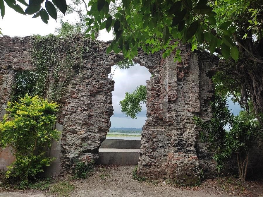
Figure 6. Iglesia de San Jacinto de Polonia ruins in Camalaniugan (Photo by M. Mabanag)
The Iglesia de San Miguel Arcangel ruins (Fig. 7) in Brgy. Nassiping in Gattaran is one of the more impressive stone structures I saw during our survey. The stone church itself is not grand nor expansive but it is still functioning, under the care of the barangay. Aside from the church structure, there are the ruins of a convent located within the church grounds. Starting as a mission under the patronage of Santa Catalina, Virgen y Martir in 1596, the church’s name was changed to the present patron saint in 1604. There is no exact date for the establishment of the stone church; however, it is believed that it predates the construction of the Santa Catalina Church in Gattaran (Noche 2004).
In Brgy. Centro Sur, the church of Santa Catalina de Alejandria can be found. The red brick church was completed in 1739, but started as the mission of Gattaran in 1623. After its completion, Santa Catalina supplanted Nassiping Church as the town’s main church. As it stands now, only the apse may be attributed to the historic church. The majority of the church has been renovated as it was destroyed during the Second World War (Noche 2004; Jose 2020).
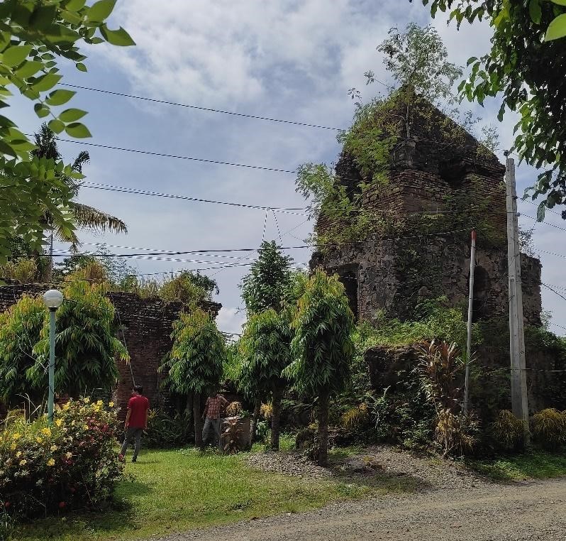
Figure 7. The Iglesia de San Miguel Arcangel ruins in Gattaran (Photo by M. Mabanag)
When we arrived at Tocolana (Fig. 8), Mylene muttered “Angkor WHAT?!” And I agree. What we saw is an example of monumental architecture, or at least the ruins of, that I normally do not associate with the Philippines. The view before us was what remains of the grand stone structure. Tocolana was one of three parishes in Lalloc or Nueva Segovia (now Lal-lo). The Iglesia San Vicente Ferrer de Tocolana is projected to have been erected within the 17th Century. The records are scant about the history of Tocolana, but what is known is that it became a Spanish mission in 1604. Sometime after, beginning in 1692, it was subsumed under Camalaniugan and then again under Lallo from 1708-1773 (Jose 2019a).
Aside from Tocolana, San Pedro (Cathedral of Nueva Segovia) was also one of the parishes established in Lal-lo (Noche 2004). The site of the old cathedral ruins is in what-is-now Brgy. San Jose, and ceased to be used and abandoned in 1790 (Jose 2019a). It was then used as Casa Real, the office of the Alcalde-Mayor (equivalent to Provincial Governor in today’s times) of Cagayan before the capital was transferred to Tuguegarao. Then, in the late 19th Century, the Tabacalera offices and warehouse were built over the ruins (Jose 2019a). Presently, there are still red brick walls and arches at the Casa Real site which is now part of a community of residents.
The only standing parish of the original three of Lallo is the Iglesia Santo Domingo de Guzman. Santo Domingo was established as a Dominican house in 1598 in a new settlement called Bagumbayan for non-Cagayanes. The church itself cannot be dated based on historical records, but may have been erected in the 17th century. The church, in its present state, is probably not reflective of the historic church anymore as a result of the damages that occurred during WWII. The interior space is not the original as well and has since been remodeled (Jose 2019a).
Figure 8. Ruins of the Iglesia San Vicente Ferrer de Tocolana in Lal-lo (Photo by M. Mabanag)
Northwestern Cagayan
Aside from Nueva Segovia (modern Lal-lo), Pata was one of the earliest missions in the Cagayan Valley region. The mission itself was founded in 1595 under the patronage of Santa Maria Magdalena (Noche 2004). The ruins of the church (Fig. 9) are located off the main highway in Brgy. Namuac, in Sanchez Mira, and can be accessed by walking along a short dirt path that passes the house of the caretaker of the ruins, Mrs. Elizabeth Martinez. Pinagsimbaanan (the name locals call the ruins) is quite a large complex. There were a few instances that I thought I had surveyed the whole compound when I realized there is another part that I had not seen. Another mission, San Jose, was established in 1865 (Noche 2004).
The Saint Joseph Parish still serves as the main church of Claveria. The front of the church is renovated, but the remains of the historical church can be found in the back. There we were able to see the original stone walls that framed the structure. For archaeological research, however, the only possible location for further work is an open field in the eastern part of the church compound.
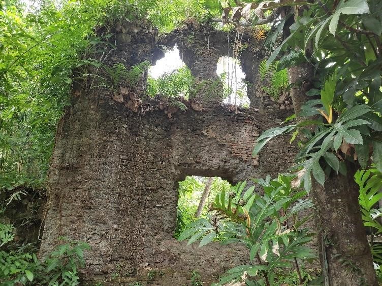
Figure 9. Wall of the Santa Maria Magdalena Church Ruins in Sanchez Mira (Photo by M. Mabanag)
Isabela
Prior to heading back to Manila, we checked off the last two sites on our list: The Roman Catholic Church of San Pablo (Fig. 10) and the San Matias Parish (Fig. 11) in Tumauini in Isabela. The ruins of the San Pablo Church, established in 1624, dominates a plaza in Barangay Poblacion. While the frontage is overgrown with weeds and appears to not be taken care of, the church itself is still very much functioning. I looked inside and there were maintenance people doing work in the interior. There appeared to be major renovations happening as crews could be seen working in the surroundings of the church.
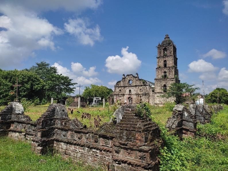
Figure 10. San Pablo Apostol Church (Photo by M. Mabanag)
San Pablo was one of the earliest Christian settlements in Isabela. It was established as a reduccion under the name Santa Catalina de Siena de Maquila along with San Pablo de Pilitan and San Ildefonso de Navalangan. Later, the settlement’s name was changed to Cabagan. In 1888, the town was divided to Cabagan Viejo (present-day San Pablo) and Cabagan Nuevo which is now the town called Cabagan (Jose 2018).
The church in Tumauini has its beginnings as a chapel in honor of St. Matthias the Apostle in 1707, with construction of the current church beginning in 1783 (Jose 2011a). There are still bricks with the year “1783” inscribed in the walls of the church. The bricks used were made in the horno (Fig. 12) that is now within the West Central School grounds. We could only view the top part of the kiln as it was under a pile of sand—there is ongoing construction inside the school. While San Pablo has a frontage and spaces at the back that will accommodate a few trenches for excavation, St. Matthias is almost completely built up so that plotting a square for archaeological excavation is not feasible.
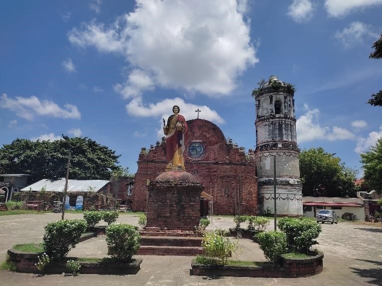
Figure 11. St. Matthias Church in Tumauini (Photo by M. Mabanag)
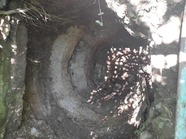
Figure 12. Horno in the West Central School in Tumauini, Isabela (Photo by M. Mabanag)
Phew! So, what’s next?
By the end of the survey, we were quite overwhelmed with the number of sites, and Mylene, Kevin and Michael assured us that there are more! A good number of the sites meet the criteria of what an ideal site is for our research. The difficult bit is trying to pare down the list to focus on sites that we will be working on in more detail for the remainder of the project. We are all foreseeing this to be a long-term cultural heritage project between the Cagayan Museum and, by extension, the Cagayan Provincial Government, the many component LGUs and UP-ASP.
What is particularly interesting to me though was a bit of information Michael and Kevin shared with me. They mentioned that there are ethnobotanical studies on the Itawit and Agta in the Cagayan Museum’s stores of documents. Aside from these, I also have an ethnobotanical survey of the Gaddangs, one of the Indigenous peoples whose homeland is centered in Isabela and Nueva Vizcaya prior to the migration of the Ilocanos from the northwest of Luzon. Cagayan and Isabela are long known producers of tobacco (H. Nicotiana tabacum), cacao (J. Theobrama cacao) and corn (P. Zea mays)— crops all introduced during the Galleon Trade from the 17th to 18th centuries.
Soon, I hope to be able to look for, and study, plantations of these New World species to understand how human-environment interactions in these areas may have changed from the time before the Spanish arrived to the present times. The Itawit, Agta, and Gaddang ethnobotanical records are potentially useful resources for my research in this regard as these offer me a baseline from which I can measure against plant remains we may be able to collect in the future.
References
Jose, Regalado T. 2011a. A Visual Documentation of Fil-Hispanic Churches Part III: Tumauini, Isabela. Philippiniana Sacra 46 (137): 383-418.
Jose, Regalado T. 2011b. A Visual Documentation of Fil-Hispanic Churches Part IV: Parish Church of San Raymundo de Peñafort. Philippiniana Sacra 46 (138): 693-730.
Jose, Regalado T. 2018. A Visual Documentation of Fil-Hispanic Churches – Part XIX: The Church of San Pablo Apostol in Cabagan Viejo (Now San Pablo), Isabela. Philippiniana Sacra 53 (160): 527-588.
Jose, Regalado T. 2019a. A Visual Documentation of Fil-Hispanic Churches – Part XX: The Churches of Lallo and Tocolana in Cagayan. Philippiniana Sacra 54 (161): 69-124.
Jose, Regalado T. 2019b. A Visual Documentation of Fil-Hispanic Churches – Part XXI: The Church of San Jacinto de Polonia in Camalaniugan, Cagayan. Philippiniana Sacra 54 (162): 317-350.
Jose, Regalado T. 2020. A Visual Documentation of Fil-Hispanic Churches – Part XXV: The Church of Santa Catalina de Alejandria in Gattaran, Cagayan. Philippiniana Sacra 55 (166): 499-532.
Macarrubo, P.W. 2019. Tuguegarao’s Saint Peter’s Cathedral: Its History and Conservation. Philippiniana Sacra 54 (163): 499-534.
Noche, Manuel M.L. 2004. The Dominican Missionaries in the Cagayan Valley: Their Missions and Architecture. Philippiniana Sacra 39 (117): 533-578.
Acknowledgments
We would like to express our gratitude to Mayor Maila Rosario S. Ting-Que, the Tuguegarao City Government, and Mr. Raul Ting for hosting the survey team during our time in Cagayan.