
The search for potential areas for study for the PANTROPOCENE project continues. As part of a group of archaeologists from the Archaeological Studies Program (ASP) at the University of the Philippines, I recently went to survey sites in Laguna, Batangas, and in Tayabas in Quezon Province (Fig. 1). The first leg of the survey targeted areas that ringed two of the major lakes in Southern Luzon, Laguna Lake and Lake Taal. The research team also targeted places further afield such as Nasugbu in the western coast of Batangas Province. The majority of the sites have been documented in historical texts and archaeological report write-ups. Meanwhile, one site, The Balai Isabel Ruins, has already been investigated by a one of the team members, Taj Vitales, as part of an assessment study by the National Museum of the Philippines.
Taj was also instrumental in selecting the sites to survey. He had done extensive research when he was writing up his report at the conclusion of his Balai Isabel project back in 2011. Armed with his notes, one of the first sites we looked into was the Lumang Simbahan ng Pila (Old Church of Pila) that was erected in 1578. The research team was looking at stone structures that were built after the establishment of the Spanish Empire in the Philippines. The stone structures may include churches and houses (called bahay na bato). Dr. Grace Barretto-Tesoro, the head of the ASP and a senior coordinator of the PANTROPOCENE project, is interested in testing the correlation between the construction of these stone structures with changes in settlement patterns as well as the environmental effects these changes initiated.
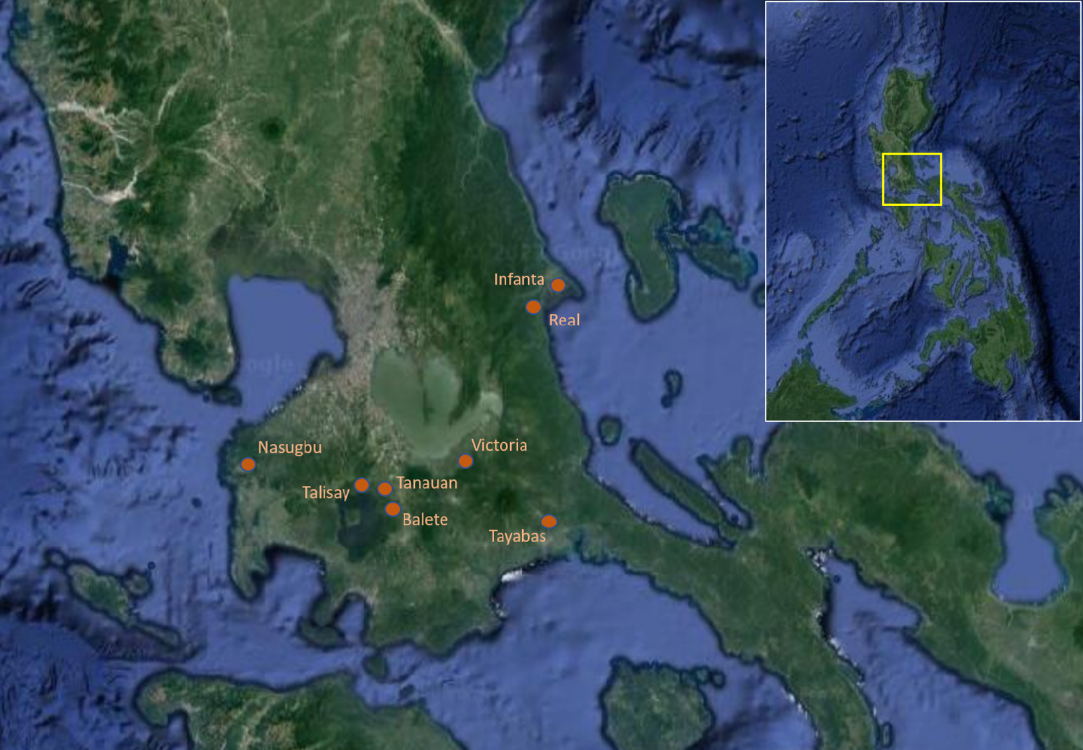
The Old Church of Pila (Fig. 2) site is located in what is now the town of Victoria in Laguna and sits just a few metres inland from the flood plain of Laguna Lake. We also took the opportunity to test the feasibility of conducting coring activities near the shore of this lake. Emil Robles, another member of the team with extensive experience in collecting palaeoenvironmental core samples, brought along a few metres of extension rods of a core auger to test the nature of the sediments. The sediments near the shore are much too compact. A viable coring site would be located a few metres further into the lake.
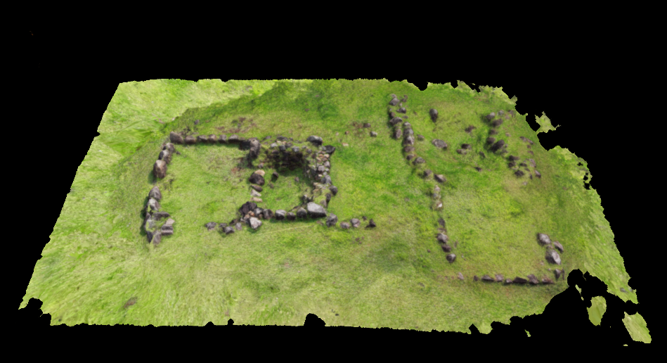
The next site is located in the town of Talisay in Batangas and has been called the Balai Isabel Ruins. The National Museum was called in for assistance when an accidental discovery of human remains occurred during landscaping activities within the confines of the ruins in 2010. In all, there were five sets of human remains uncovered, however it is believed that there may be more. There was also an adobe structure and possible flooring made out of plaster exposed. Taj has concluded that the ruins could represent the Old Tanauan Church, which acted as the centre of the Talisay barrio up until the late 1800s. This could also explain why there were burials inside (Vitales et al. 2011). The extent of their excavations spanned only the southern end of the ruin structure. Further investigations in the other parts of the ruins may yield more information. Aside from this, plotting excavation squares in the areas outside the ruin structure may prove to be fruitful as well. These areas appear not to have been heavily disturbed.
Next up was the site locals have been calling Pinagsimbahanan in Barangay Bañadero in Tanauan. This is the Old Sala Church. What we saw was the edifice of the old church, but the main ground had been developed into a small park. The extent of the ruin complex stretched about twenty metres along a narrow street that has been dotted with many residences. The main path was cemented as well after pipelaying activities to supply residents with water. As a result, we decided not to pursue Pinagsimabahan as a site for further research at this stage.
The Old Lipa Church, or the grounds where it once stood, is located in the town of Balete. Previous visits of senior archaeologists from the National Museum confirm that there once stood the remains of walls of a stone structure. What we saw was a compound that was halfway to being converted into a commercial area. However, there were still areas that had yet to be developed where we found a few pieces of earthenware pottery and a few pieces of tisa (brick) and stone blocks. We were able to speak to a resident of the property that seemingly shared the same land (there were no discernible boundaries or fences), and were told that he remembers that there were a few standing walls when he was young, and elders used to remind the children not to play around the “old church.”
The present state of the grounds of the church, with construction ongoing in at least a portion of it, leads us to see an opportunity to conduct a small sample collection program in the property. The goals of this investigation would be primarily to collect macrobotanical and other plant remains that could provide insights into the surrounding environment prior to the establishment of the stone church. A reference that Emil was able to dig up was by Buloz and le duc d’A (1870) published in Revue des Deux Mondes amounts to a travelogue of the two in Luzon and Mindanao. Part of their account details past crops that were abundant in Tanauan as well as Lipa. Buloz and le duc d’A mentions that Tanauan was known as an abundant source for abaca and cotton, while Lipa had coffee plantations. These are primarily cash crops, it seems, and I am keen to find out what the assemblage from the excavations will reveal in this regard.
Much further, near the coast of Batangas, the town of Nasugbu offers two sites that are ripe for more research. The outer walls of the Lumang Simbahan still stand to this day, however there is a smaller church which serves as a place for devotion for the devout. While the site is an active church, and, therefore, can be very busy especially on Catholic holy days, the owners of the site are open to having systematic archaeological excavations be conducted. It is through them we were able to identify potential areas in which we could collect samples. The excavation program at the Old Church of Nasugbu will mirror that of Old Lipa. It will strictly take the form of sample collection for macrobotanical, phytolith, and pollen remains owing to the nature of the church as still being actively used.
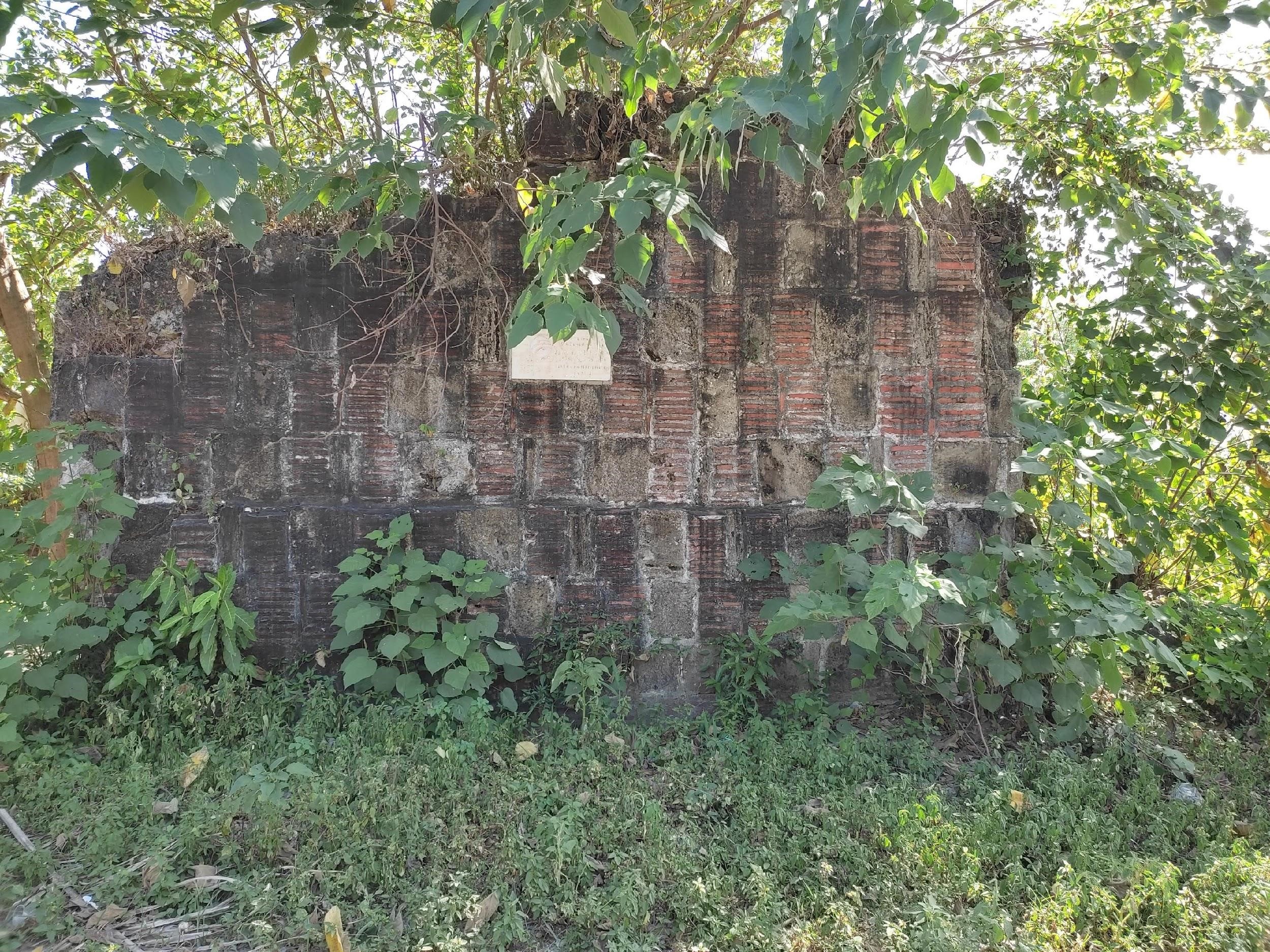
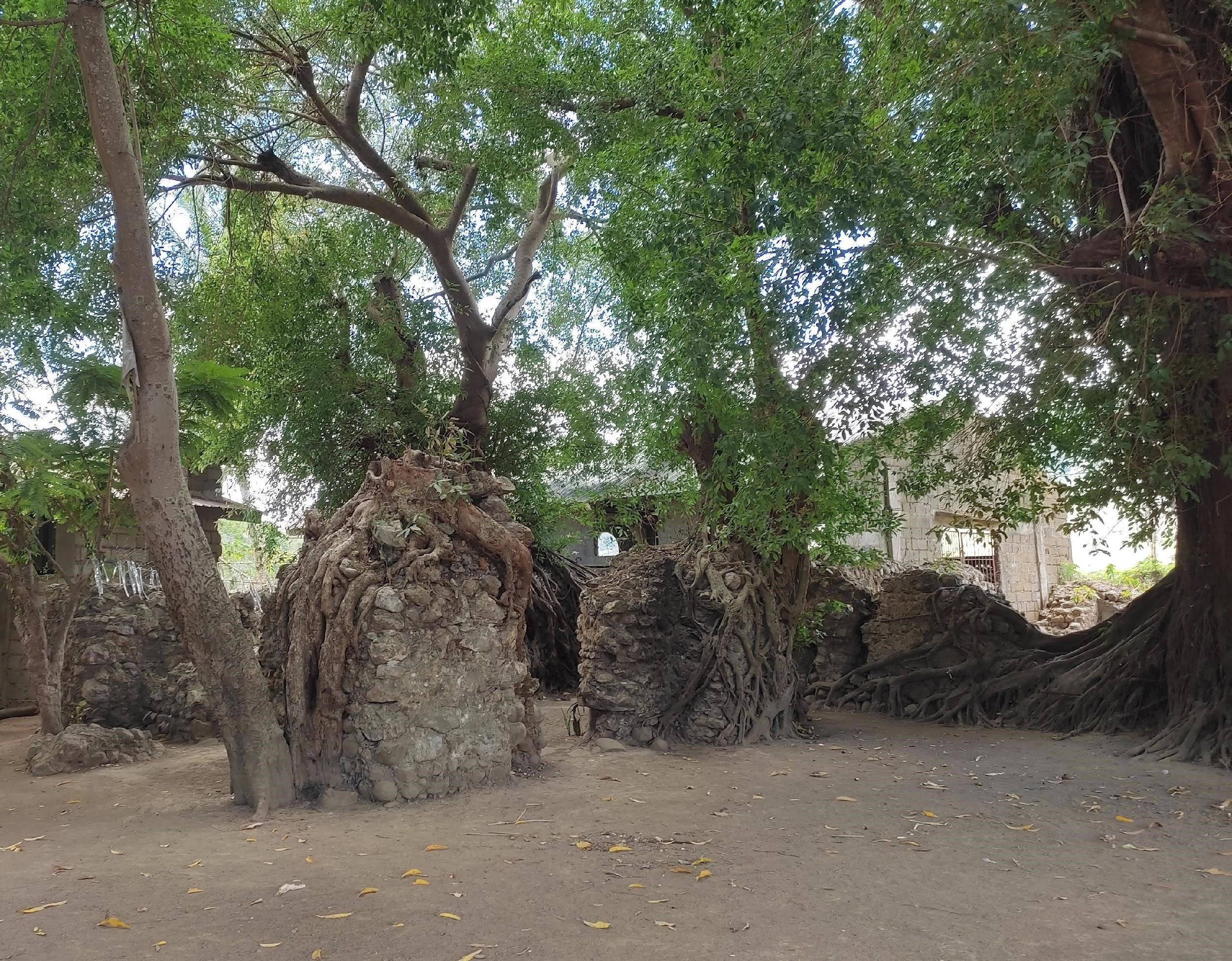
One of the surprise “discoveries” from our survey in parts of Laguna and Batangas is what people call “Kumbento” (or convent) (Fig. 3). On at least three separate occasions, we were informed of another stone structure that is not well known to anyone apart from the local residents. True enough, the place is quite unlike what I have seen so far. Unlike the stone structures (or the remains of) we have surveyed, Kumbento has spaces that are discrete and not connected to other parts of the complex. One is given the impression that the space is not open. The site is not a public space, and could very well be what its name suggests, a convent or a living space. The site is about 16 kilometres north of Lumang Simbahan, off a dirt road that bisects hectares of agricultural fields. Fortunately, the owners of the property live on-site, their house is just “outside” the ruin structure. As of this moment, we foresee a more extensive excavation program (the same as in Balai Isabel Ruins) with multiple trenches in different parts within and outside of the ruins. For my archaeobotanical research, plotting at least one archaeological square in the agricultural field on the other side of the dirt road from the site would be ideal.
Another leg of survey work started the beginning of June. With the same team, we went off to Tayabas in Quezon Province, around 130 kilometers south of Infanta and Real. Like those northern Quezon towns (as the majority of the Philippines are), Tayabas represents a place that underwent massive changes brought about by the incorporation of the country into the Spanish Empire. The establishment of churches, construction of stone arch bridges and the start of industrial farming are but a few examples of these.
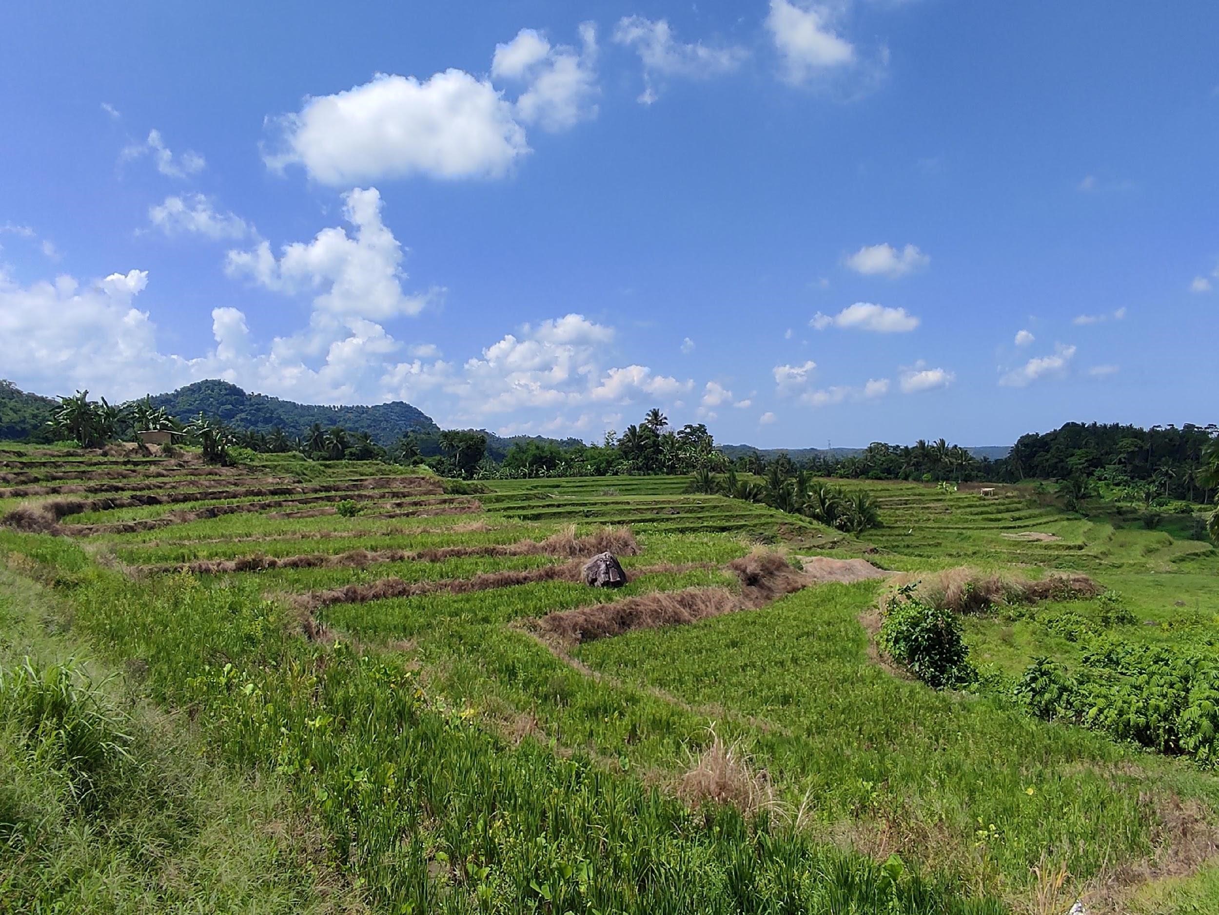
One of the sites I am most eager to conduct research on is what Tayabasins call Altaran (Fig. 4). Though there are numerous examples of terracing that dot the landscape (even in low-lying areas), Altaran specifically refers to a particular area of rice terraces found in Barangay Dapdap whose contours resemble that of a theatre. An anthropologist. E. Arsenio Manuel (1994) suggested that the terraces found in the lowlands are precursors to those found in Northern Luzon. The terraces in Brgy. Dapdap are about 500 metres above sea level and most are still active rice fields. Fortunately for us, we were able to speak to a landowner who was open to having her land be subjected to archaeological excavations. Upon visiting the rice field, we were informed by one of the workers that the original riprap was there and had been there ever since he could remember. We agreed that we would time our fieldwork to take place after harvest season in December.
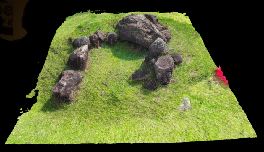
Taj and Emil were tremendous sources of information during our survey. They did a weeklong survey more than a decade ago in Tayabas connected to a different project. It is from their notes that we visited a property on the outskirts of town in Brgy. Alsam Ilaya. Based on their notes, they interviewed the landowner and he informed them of large stone implements around their barangay. He also showed us a few large stone implements that he had in his residence. After this, we were accompanied by his son to a parang (cleared field) in the midst of rice fields and tree plantations that had a few more of these stone implements such as iluhan (stone press), lusung (stone mortar), labangan (stone basin), banga (stone vat), and bunsuran (stone foot mat). Aside from these, the undulating parang also had large stone pieces (Fig. 5). We were able to map these structures and Emil produced a 3D sketch (Fig. 6) of these. Taj has a suspicion these stone structures are what remains of a copra processing operation. The landowner’s son appeared to confirm as much when he said that the parang used to be the location of a coconut tree plantation according to the story of the original owner from whom his father bought the property.
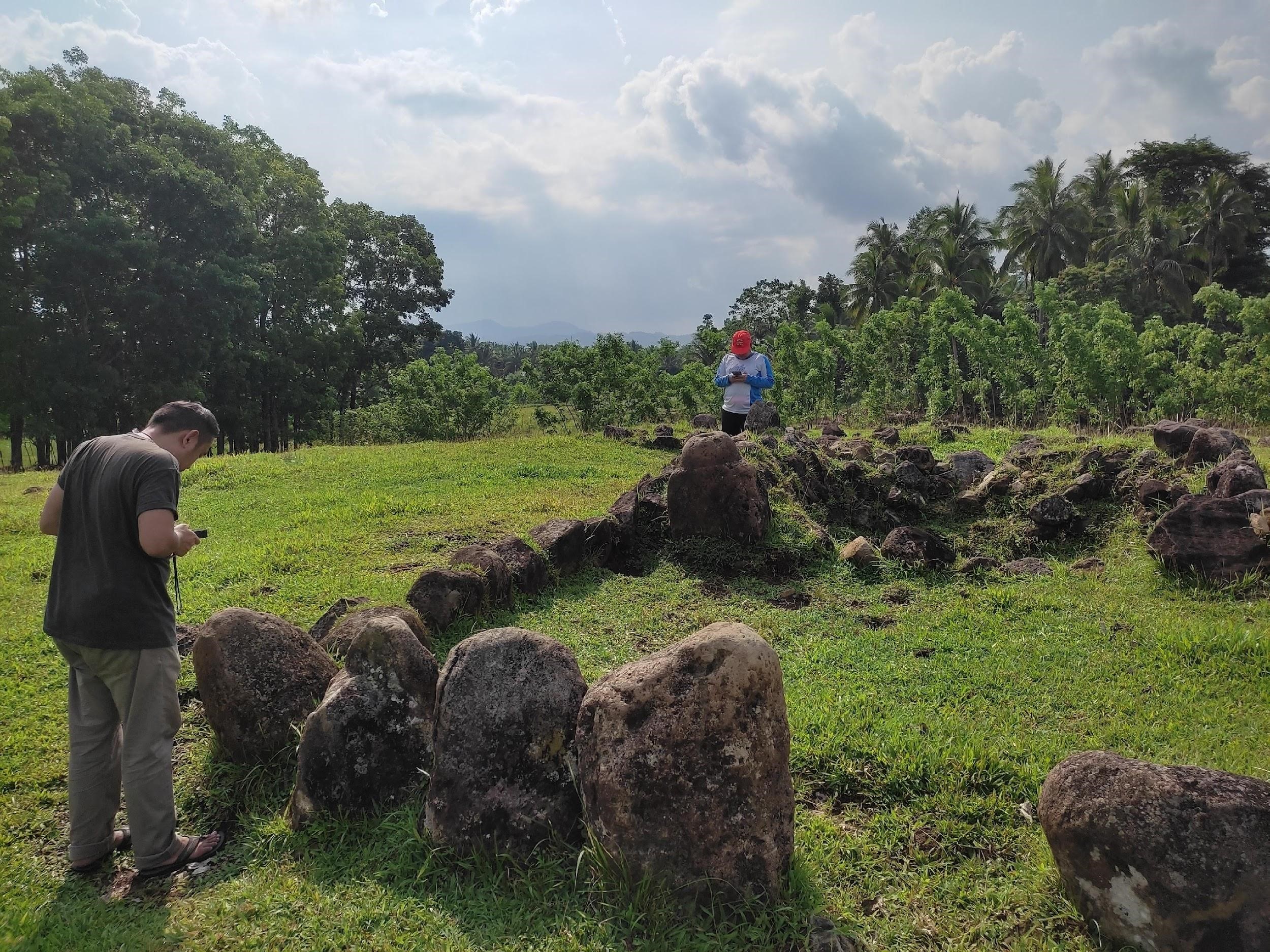
Initial talks with the landowner led us to believe we may be able to launch a full-scale excavation program at the site. Some initial questions that I would like to answer include: When was the coconut plantation converted to a parang? Prior to being a coconut plantation, what were the original plant species that dominated this landscape? Did the conversion to a coconut plantation coincide with the drive to produce more coconut by-products during the time of Spanish colonization?
Aside from the stone implements, the landowner also informed Taj and Emil during their previous initial meeting of the locations of stone crosses that is unique to Tayabas. We were able to see one up close in a property owned by a neighbour. The stone crosses, the local story goes, are related to the early pre-Hispanic belief system. The stones are attributed to having a spirit living within them, and local Tabayasin still call these buhay na bato (living stone). These stones were repurposed into the shape of the cross when Christianity began to proliferate in the Philippines.
During our last day of survey in Tayabas, we visited the Cultural Heritage Preservation Office in the Tayabas Municipal Hall. There we met the head of the CHPO who provided helpful information. The Spanish Colonial Government in the Philippines imposed an order in an edict presented by Governor General Sebastian Hurtado de Corcura in 1642 that all native Filipinos should plant coconut trees for the galleon trade. The by-products, such as coconut water for the crew and husk fiber for caulking and cordage for the ships, were critical to the development of this early pan-tropical trade. This was the same argument Victor Paz, a prominent archaeologist, had offered to me before.
The possible reason for modification of forest lands in the Philippines may be due to the drive to power the galleon trade, maybe not for product-making but rather for the whole operation to run smoothly. Later on, the taste of Europeans for margarine and soap further exacerbated the demand for coconut products such as copra and oil. This past is still very much reflected in how the land is used in the present. As of 2011, the total agricultural land area amounts to 15,806 hectares (ha) or 68.4% of the total land area of Tayabas. Of this, only 10.5% (2,428 ha) is used for rice paddies, while an overwhelming 57.2% (or 13,205 ha) is used for coconut (Tantuico 2011).
The Tayabas CHPO also informed us of a site in the city centre that is not very well known. This was the Sanctuario de las Almas that was built in 1855. Previously called Cementerio de los Españoles, the church was a cemetery and presently serves devotees at mass once a week. The compound has a frontage where we can plot a few squares for excavation. The back part of the church, behind what is now the altar, is somehow closed off and hard to access. This is believed to be the area where the clergy were buried. The CHPO is very open to collaborating with researchers to learn more about the site.
The research questions that I want to focus in on for my dissertation project are very general and can be called modular. My aim is to be able to use the greatest number of “case studies” to come to an understanding of what the ecological context was like in the Philippines prior and after the establishment of the Spanish Empire in the region. It is for this reason that Tayabas, as Infanta and Real, offers a unique opportunity for me to understand the relationships of people, Indigenous and foreign, with the environment, and the possible reasons there may have been changes in these dynamics over time.
References
Buloz, C., le duc d’A, M. 1870 Luçon et Mindanao: Recit et Souvenirs d’un Voyage dans l’Extrȇme Orient. Revue des Deux Mondes 87(2): 341-374.
Manuel, E. A. 1994. Documenting Philippineasian: An Inquiry into the Ancestry of the Filipino People, their Early Culture and Prehistory before the Christian Era. Quezon City: Philippineasian Society.
Tantuico, K. D. 2011. Pag-abyad sa Altaran: Caring for the Rice Terraces of Tayabas, Quezon. AghamTao 20: 127-145.
Vitales, T. J., Bautista, R., Pagulayan, P. 2011. Report on the Archaeological Excavation of the Spanish Period Colonial Ruins in Club Balai Isabel, Talisay, Batangas (28 February – 19 March 2011). Manila: National Museum of the Philippines.