
In late April 2023, a couple of years after the start of the European Research Council-funded PANTROPOCENE Project (and countless Zoom meetings), project personnel and collaborators came to the Philippines to participate in a workshop to discuss their progress as well as to brainstorm future directions germane to the project. It was the first time we were in the same location. It was nice to see Dr. Patrick Roberts (Max Planck Institute of Geoanthropology [MPI-GEA]), principal investigator of the project, again since 2018 when he, Dr. Grace Barretto-Tesoro (University of the Philippines Diliman School of Archaeology [UPSA]), and I had a lunch meeting during the Indo-Pacific Prehistory Association (IPPA) Conference in Hue, Vietnam. It was there that Patrick laid out the goals of the PANTROPOCENE while he was still finishing writing up the grant proposal.
Aside from Patrick, I also met other project members Dr. Greg Bankoff (University of Hull), Dr. Deepak Jha, Dr. Max Findley, and Dr. Noel Amano (MPI-GEA). Noel, I knew from before. He was a UP-ASP (now UPSA) student, and we participated in a couple of digs in Palawan and Negros. They all came with us for our field work almost wo weeks prior to the start of the workshop. Two other members of the team, Dr. Rebecca Hamilton (University of Sydney) and Dr. Jed Kaplan (University of Hong Kong) joined us on the second leg. Bec selected the coring sites from her analysis of historic and satellite maps, and published studies of the different lakes in the Philippines.
As some of the readers may already know, the PANTROPOCENE Project aims to use high-resolution data to understand human-environment interactions pre- and post-Spanish colonial rule in the Philippines. Researchers from different disciplines such as archaeology, palaeoecology, and history will be combining datasets from their respective research to reveal past land use patterns and how this may have affected forest lands in a tropical setting. As part of this research, we conducted palaeoenvironmental coring in Aparri and Gattaran in Cagayan Province, and in Palakpakin Lake in San Pablo, Laguna (Fig. 1). We also attempted to collect a core sample from Tadlac Lake in Los Baños. But we did not have the right equipment for a lake with a depth of more than 35 meters.
Cagayan
So off to Cagayan we went. The first order of business was to meet with our collaborators. Two holdovers from the survey we did back in 2022, Mylene Lising and Kevin Baclig were there. However, due to other engagements, neither were able to join us in our field work. Joshua Palolan, also from the Cagayan Museum and Historical Research Center, was there to help us. Joshua, like Kevin, is an Aparriano, and is familiar with the coring site areas in his hometown. At first, Joshua was strictly there as a guide to help us in our courtesy call visits to the different municipal and barangay offices. He was also there to document the work we were doing on behalf of the provincial government. But, in the end, he helped us in our field work in Gattaran, and he was enjoying it! We might have another budding archaeologist.
There were proposed eight coring sites in Cagayan: four in Aparri and another set of four in Gattaran. Bec had a coding system in place for sites that fit the purposes of our project. She highlighted three “Priority 1” sites in Gattaran, while all the sites in Aparri are labeled “Priority 2.” We still aimed to collect core samples in Aparri, however. So, for our first day of coring, we went to Aparri, and earmarked Gattaran for the following day.
Three of the sites in Aparri were concentrated in what locals call West Aparri. East Aparri, on the other hand, is separated by the Cagayan River from the rest of the town. The fourth coring site was in a delta. We were working on a very tight schedule—we had planned to collect samples from at least two sites in one day. The location of the eastern site would entail us to cover a 75 km drive around the river that I had, in my mind, determined we would not be able to go there. On the other hand, the western sites were situated in contiguous barangays: (from north to south) Bisagu, Sanja, and Paruddun Norte. On the day of our sample collection, we decided to go to Sanja first as the site is accessible—it is closest to the main road.
Months prior to our trip to Cagayan and Laguna, we had already acquired a coring permit from the National Commission of Culture and the Arts (NCCA) as our field work is still within the purview of archaeology. We also sent letters of introduction and requests for courtesy visits to the mayors of the towns where we will be working. On the day of our first coring activity, we made a courtesy visit to the Sanja Barangay Hall. It would have been better if we were able to do a survey of the coring sites beforehand though. This would have given us the opportunity to scout the site and maybe speak to the property owners. We had to compress all of this in one day. Far from ideal, but we did our utmost to still follow a best practices approach.
Barangay Captain Erwin was very generous with his time. Not only did he welcome us during our visit, but he also offered any help we may need for our coring activity. We took him up on his offer. However, I thought he was going to ask one of the tanods (barangay police officers) to help us. I was surprised when I saw him putting on his military boots. He also roped one of the tanods and a whole crew of high school students doing externship in Sanja. It appears that Cap Erwin was a military man, and he was teaching these students basic survival techniques.
Patrick and I were happy to see we had high school students helping us. We had a load of equipment to carry and the site was at least 1.5 kilometers away northwest from the Sanja Barangay Hall. And this was walking through fallow, dry paddy fields that have been tilled in preparation for the coming watering season. And we still had to find the coring site. We have the location on the map, but we have not seen it up close. There were a few wrong turns along the way. We had to check and recheck the location of the site on the map. It did not help that we were walking on uneven fields full of holes. In some portions, we had to walk through very muddy areas where I think irrigation for the field flows through. Around half a kilometer away from the site, we began to walk on a muddy field. At different points, I got stuck in mud. That was a common occurrence for me. I think I fell on the seat of my pants at least four times that afternoon/evening because I got stuck.
Prior to heading out from the barangay hall, I asked Cap Erwin if he knew who the owners of the property where the site is located but he did not know either. He assured me that we can ask people we meet along the way. However, we did not encounter anyone on the way there. During my research to locate the sites, I learned that the site was under Sanja’s jurisdiction. Cap Erwin was sure as well when he looked at the map. He was very sure that whoever the owners were, we would be able to get their approval because he was helping us and the site was not being currently used. After a brief consultation, we decided to continue and concluded we can look up the owners post-field work to get their approval.
(Full disclosure: I was able to check with the Aparri Mayor’s Office and confirmed that the coring site is in Sanja. However, due to time constraints, we were not able to get permission from the property owner prior to us getting our core samples. I have since spoken with the son of the property owner of the site, and they are still mulling over whether to grant us permission.)
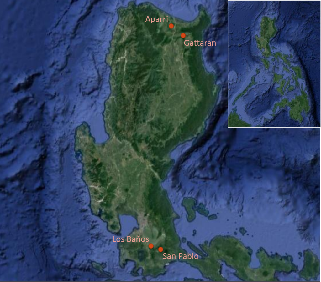
The way to the site was tough, but so was working there. The site (Fig. 2) was swampy, and had a very peaty, dead organic stench to it. I would forget about the stench, but every so often, I would get a whiff and be reminded of it. (Bec said these proved the site is a good one. So “Yay!” I guess…) Driving the D-section corer to get samples was easy enough. The core head went down easily, but what we had problems with was that each time we had to drive down the corer, we would sink into the mire as well. It was worse when we tried to pull out the corer to retrieve our samples.
It was slow-going, but eventually we were able to accomplish what we went there for. We were able to collect two core samples. Sure, it took us roughly four hours and, at this point, the sun had gone down already and we were walking back part of the way to the main road in darkness. Cap Erwin, Tanod Ben, and the high school boys were invaluable in accomplishing anything that day. It was a very tiring day. And we still had another site to core the next day.
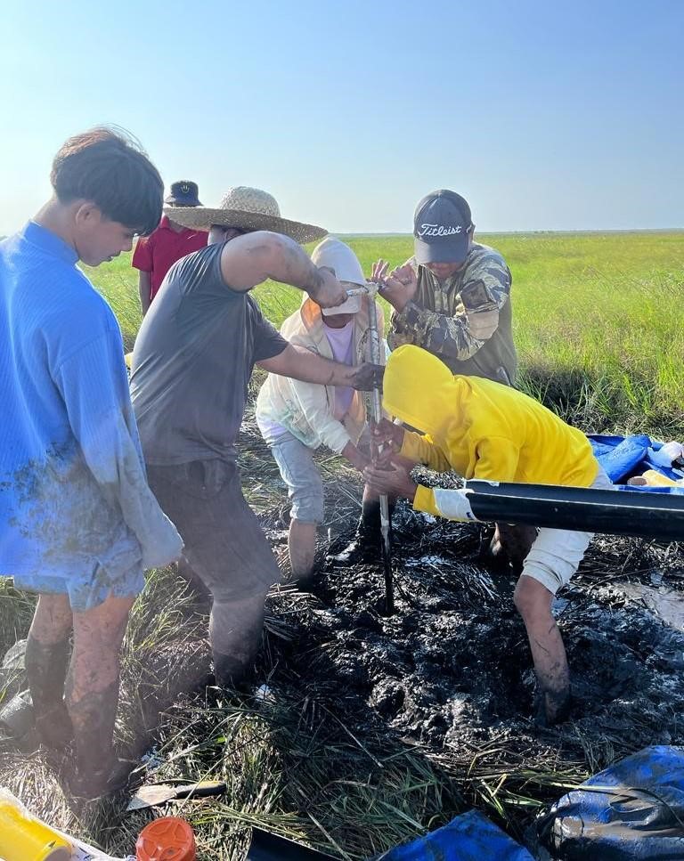
Gattaran, a town southeast of Aparri, had three primary sites located in Barangay Mabuno. The sites were easier to get to. They were on the other side of a tributary of the Cagayan River, but we were able to drive our vans through a shallow part of it. After, it was only a few meters walk to arrive in a marshland. It was scorching hot (it was mid-summer in the Philippines) and there were no trees around that would give us shade, but every now and then there was a light breeze. The site was idyllic —there were small-sized fallow paddy fields near the marshes and small rolling hills in the surroundings. Add a nice bright sunny Sunday morning, and it was a perfect place to work.
Like in Paruddun Norte, people we met at Mabuno were top-notch. Barangay Captain Hernes helped us in our coring. Kagawad (Filipino word for “councilor”) Marlone, Manong (“older brother”, a corrupt form of the Spanish hermano) Josue, Chris, and Robinson were all untiring in helping us. And all were very quick to learn how we do things.
We picked a spot on the southwestern edge of the marshland as our site (Fig. 3). The ground was soft and we still would sink down whenever we drove or pulled the corer but it was miles easier than what we encountered in the previous site. There were a few rough patches, but we were able to work around them. We all worked together, like what we did in Paruddun Norte. Some folks were primarily muscle. They initiated the drives and pulled out the corer after. Others worked on documenting the sediment matrices from each drive while another set helped each other in packing and labeling the samples. It was not all smooth sailing but everyone was willing to help and that made for a great working environment.
We collected three core samples from Mabuno. But our second core was, by far, the highlight. We reached a depth of two metres for the sample. Patrick said that it is the longest core sample to come from Northern Luzon, at least. I hope it’s enough to cover a time period of about 2,000 years to the past.
Laguna
The day after we arrived in Manila from Cagayan, we travelled a short distance to continue our coring activities in Laguna. Aside from a coring permit from the NCCA, we had also acquired a permit from the Laguna Lake Development Authority (LLDA). The LLDA’s responsibilities include the preservation, development, and sustainability of Laguna Lake, its major tributaries, and all the lakes in Laguna. Our coring site is Palakpakin Lake. It is the smallest of the seven lakes in San Pablo City. It has a surface area of 0.48 km2 and a maximum depth of 7.0 metres. Like all the lakes in the city, it was formed from the phreatomagmatic explosion of dormant Mount San Cristobal in the border of Laguna and Quezon Provinces (Aguilar et al. 2022).
We have been using a Russian D-section corer to collect samples so far. The sites up north in Cagayan were all dried lakes, and Lake Baao in Camarines Sur which we cored last year is shallow enough (< 1m) so the use of a D-section corer was appropriate. Palakpakin was too deep, however.
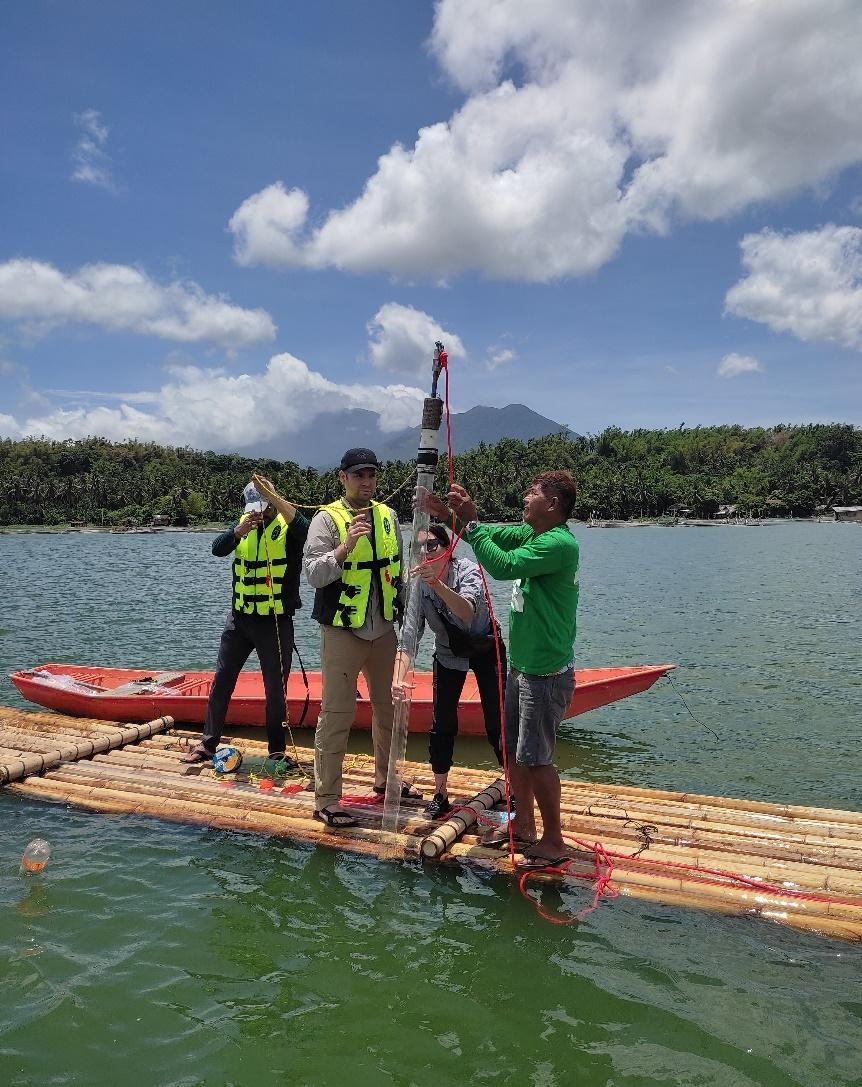
We also needed a coring platform. And because Laguna was a much shorter trip than going to Cagayan, I was able to go on a scouting trip back in March. It was during that time I was put in touch by the LLDA with the San Pablo Fisheries Management representative Nomer Rivera. After a few message exchanges and a few phone conversations (I only met Nomer on the day we were getting our sample), he suggested that our coring platform (Fig. 4) should be a twin lamo (a long, slender barge made of bamboo) lashed together by bamboo poles that will provide stability. The space between the lamos would be our moonpool. Nomer and fellow fisherfolk Kuya (Tagalog word for “older brother”; derivative from the Chinese word) Ingkiyo, Jayson, and Randy constructed our coring platform a day before we arrived. For added stability, they also attached four sacks full of sand to the four corners of our platform and dropped these into the lake for anchorage.
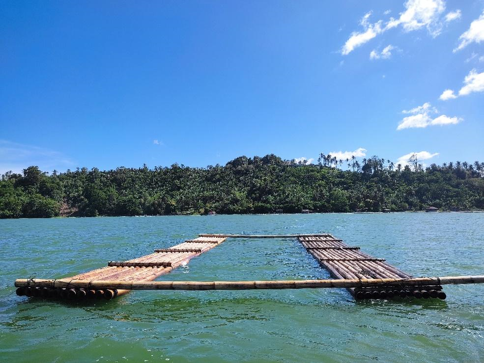
They installed our coring platform in the middle of Palakpakin. There is a quarry site near the inlet and sand from the quarrying activities has continued to be deposited into Palakpakin. Bec wanted to avoid this area. Aside from this, Bec was also working under the assumption that the centre of the lake was where the deepest area would be. Plotting our coring site location there would give us a far better chance of getting a long, continuous depositional record.
Bec brought along a universal corer that will do the job. A universal corer is used to collect long undisturbed cores with minimal effort and sample disturbance. Samples from deep lakes are collected through a gravity weight that hastens the lowering of a polycarbonate tube into the lake bed. Patrick, Deepak, Bec, and Kuya Ingkiyo took turns at initiating the drives (Fig. 5).
What struck me though was how different core sample collection is using a universal corer. I had gotten used to using a D-section corer. For the latter, multiple drives in the same hole are needed to get to an acceptable depth and, therefore, a sufficient amount of sample. I had assumed we would be doing the same for the universal corer. Bec explained to me that we only needed to do a single drive per sample core.
This is different from a D-section corer. Each time we retrieved the corer after a drive, we would put a “marker” (using a guide tube is ideal) on the spot. We also made sure to not disturb it as we will be inserting the corer back to get more samples. Using the universal corer we had, the core tube was lowered through a system of ropes where a person releases a rope with a gravity weight to drive down the tube deeper into the lake bed. Another rope was used as a guide for the collecting tube as well as a marker for the depth we reached at each drive. We would stop lowering the gravity weight when there was resistance and we saw the tube was not going any deeper. The collecting tube was pulled out and the sample was secured by placing one cap at the bottom. Holes were punched into the upper part of the tube to drain the water that was captured. The excess part of the tube was cut and the upper end of the tube was also then capped.
In all, we were able to collect four core samples—all cores measuring slightly less than two metres. Bec was happy with our haul. She will be extracting and analyzing pollen from the samples we collected. Deepak, for his part, will work on analyzing plant biomarkers and stable isotopes. The results of their analyses will form the backbone for a regional-scale picture of environmental change in the Philippines.
References
Aguilar, J. I., Mendoza-Pascual, M. U., Padilla, K. S. A. R., Papa, R. D. S., and Okuda, N. 2022. Mixing regimes in a cluster of seven maar lakes in tropical monsoon Asia. Inland Waters 13 (1). doi/full/10.1080/20442041.2023.2167484?src=