By Marvin Dorosan
Research Associate, PANTROPOCENE. Graduate Student, UP School of Archaeology
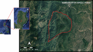
The Municipality of Asipulo is located south of the province of Ifugao in Luzon, Philippines, landlocked by the municipalities of Kiangan in the north, Tinoc in the west, Lamut in the east, and the province of Nueva Vizcaya in the south (Figure 1). Given the location of the municipality, the landscape is described as having very rich vegetation ranging from forest trees to agricultural crops.
Some parts of the municipality were carved into terraces catering to agricultural products like rice and vegetables. The produce from these small lands were either for personal household consumption or were exported to nearby municipalities. While there is general access to Asipulo, it was still challenging to reach the municipality because of steep elevations and narrow roads. Thus, walking and hiking are more convenient if one plans to survey the municipality. Various animals were also found in the area, but cows and carabaos were observably scarce. When the locals were asked, they mentioned that the use of carabaos and cows in the province is not that common nowadays because the areas being cultivated are not that huge and it’s more efficient to attend the lands manually. River systems were also identified.
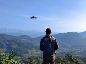
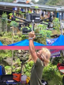
During our stay from 3-14 April 2025 in Asipulo, 1000 ha worth of both photogrammetry and LiDAR data were collected from the northern area of the municipality. The barangays that were covered by the remote sensing were Amduntog, Antipolo, Nungawa, and Haliap. Before conducting the flights using the drones, courtesy calls with the previously mentioned barangays and the municipality were performed. An initial pedestrian survey was also conducted in the first few days of our stay in the municipality to identify points of interest and take-off points, and to scout the area for logistics. Several areas of interest were identified such as the rice terraces in Brgy. Amduntog that is well kept and in Brgy. Nungawa which still has retaining walls constructed using stones. There were also agricultural terraces that were found to be abandoned for years that were now covered with trees. All of these features were properly documented and considered in the final flight plan.
The conduct of remote sensing in Asipulo was not without challenges. To start, the landscape of the municipality is a major challenge in itself. There were areas that were hard to reach without heavy-duty transportation. Aggravating this challenge was the need to hike certain areas while carrying heavy equipment. The transport of these equipment consumed a lot of time, which was another challenge. Given the nature of data collection, time is of the essence to the team. The data collection of the LiDAR does not depend on the light conditions, so it was continuous throughout the fieldwork. Whereas the photogrammetry depends highly on the length of the shadows, which are the shortest in only two situations: (1) during the window times of dawn and dusk or (2) during noontime when the sun is at its zenith.
Provided with the challenges mentioned, ample time for planning fieldwork in such landscapes is recommended. This was already a given, but because of the limited time that the campaign has for this, planning is done while simultaneously performing the tasks for the fieldwork. Furthermore, prior training of team members (especially those that were new to the methods) and acquisition of extra equipment (if possible, like the small drones) could have been done to effectively divide the team since there were multiple take-off points that required time to reach. However, this also needs additional people and resources since the number of equipment will also multiply.